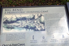
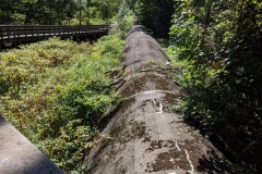
Another great day! First, I apologize for the few pictures as my phone camera malfunctioned- not sure why, but it has been giving me problems. We decided to hike this section of BT to be in the woods more and in the city less. For the most part this worked out; early on the trail was a dirt path in the woods and as we approached Akron we were on the towpath but surrounded by woods. There was a major detour, going on for years it seems, right at the city edge that takes you off the towpath and through city neighborhoods. Right from the beginning of hike you parallel a HUGE sewage pipe out of Akron for miles that ends at a treatment plant out by Bozum- kinda yucky to think about but truly impressive in scale and length- just a long enclosed concrete viaduct. The second most impressive thing were all the locks along the towpath as you approached and entered Akron. The city has done a really nice job highlighting this feature of history. There was a nice mural under a city bridge demonstrating the number and location of locks between Cleveland and Akron, and the steep elevation changes and increased frequency of locks as you approached Akron. Wendy remarked “Maybe that’s why they call it Summit County!” She may be on to something. By similar reasoning, Portage County may be named because this is where the Tuscarawas and Cuyahoga rivers are the closest, and Indians/traders had to ‘portage’ their boats and goods between the two rivers. It seems also where the water source for the canal switched. Really interesting, right? Too bad my many pics didn’t make it so you could read about it for yourself.
WELCOME to Creeping along the Blue Blazes!
A blog recounting our slow-paced journey along the Buckeye Trail


